- Operating in such a remote environment as Scoresby Sound presents some fairly unique challenges and rewards.
- The attractions of the region lie in the fantastic scenic beauty provided by the combination of fjords, mountains and ice [and] the wildlife.
Arctic Greenland Adventure
In an exclusive for PBR magazine, Peter Talbot discusses his three-week SIB adventure in Arctic Eastern Greenland, outlining both the attractions and challenges of open boating on the remote Scoresby Sound …
‘Hurry Fjord’s normally completely clear of sea ice by the last week in July,’ said Paul as we sat in a Wooler pub planning our adventure. While most of our preparations had shared similarities with those of earlier journeys, this was the first time Tom or I had needed to take sea ice cover into account before a boat trip. After finalising the dates and flight arrangements based on his advice, Paul mentioned that we could track the sea ice cover by viewing daily satellite images online. With only a month to go, there was still extensive sea ice in both Hurry Fjord and Scoresby Sound, but as predicted, the seasonal melt started soon afterwards.
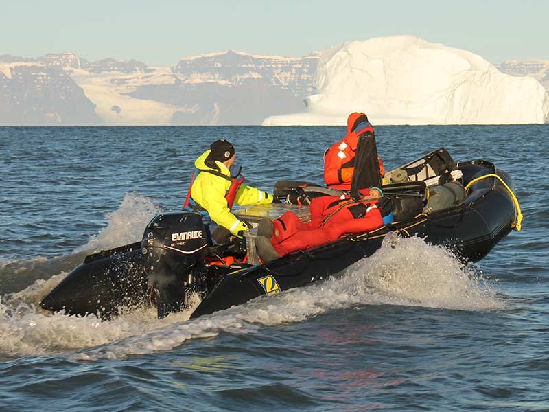
I’d kept in touch with Greenland expedition and logistics specialist Paul Walker (director of Tangent Expeditions) after an earlier ski touring expedition in Greenland, journeying 100km from the Knud Rasmussen ice cap to the Watkins Mountains, camping as we went, pulling sledges and making a few first ascents of peaks en route. Paul had since built up a snowmobile logistics operation to support expeditions in late winter and early spring, via trips over land and sea ice. More recently he’d started operating two inflatable boats to support expeditions during Greenland’s brief summer. Having owned a couple of small Zodiacs over the last 10 years and enjoyed multi-day camping journeys in a number of locations, including Sweden, Norway (see feature in PBR 124) and the west coast of Scotland (see PBR 132), I was keen to combine my interest and experience in SIBs (soft inflatable boats) with a desire to return to Greenland. Following a few emails, a plan started emerging that would see Tom (a friend I’d met when we’d both helmed safety boats at our local sailing club) and I in Greenland for just over three weeks. Tom and I would have sole use of Paul’s two SIBs (a 5.4m Mk IV HD Zodiac and 4.7m HD Quicksilver) for most of the time, and we would also assist Paul in supporting a couple of other expeditions that he’d previously committed to. This arrangement for sharing the boats would help reduce the costs of this self-funded adventure (compared with if Tom and I had wanted exclusive use of the boats for three weeks). The need to share the cost of logistics and resources (to make such remote adventures viable) often necessitates arrangements like this between groups.
We aimed to use (and build on) our previous boating and expedition experience in the remote setting of the fjords of Arctic Eastern Greenland. We wanted to see as much of the area as we could in our time there and also hoped to survey some bird colonies for a researcher friend in Denmark.
Flying to Reykjavik, Iceland, from Glasgow, we caught an evening connecting flight north to Akureyri. Good weather gave us great views of first the Langjokull and then the Hofsjokull glacier as we crossed Iceland’s interior. Awaiting our flight to Greenland the next morning, Tom bought a hot lamb-topped roll at the airport with his credit card, and before taking a second bite had received a text alert from his bank informing him that his card had been used abroad. We were impressed by the efficiency of the bank, and then the airport, as a clear 40 minutes ahead of schedule we took off in the Beechcraft King Air 2000, along with five other passengers, for the 90-minute flight to Constable Point airstrip (CNP) on the east coast of Greenland. Built in 1985 by a Canadian oil prospecting company, CNP was designed to last five years. It’s still going strong over 30 years later, and provides connections (via helicopter) to the village of Ittoqqortoormiit, and acts as a miniature hub for the small number of research scientists (we met different groups studying foxes, birds and dinosaur bones) and adventurers who visit the region. Paul’s got a logistics base at CNP, on the side of Hurry Fjord, comprising a ‘Weather Haven’ tent and five shipping containers. Four are raised about 1.5m off the ground to help prevent snowdrifts accumulating against them in the winter, and to protect them from the water ‘run-off’ snowmelt in spring (which can’t drain through the permafrost, so travels above ground on its way to join the waters of Hurry Fjord).
A smooth journey meant that after leaving home early one morning, we’d arrived in Greenland by lunchtime of the next day and were out in the boats that evening. In the brief Greenland summer, the trend is for daytime breezes to drop late in the evening, so with 24 hours of daylight, most boating is done at night with its lower winds and calmer water. While there’s no slipway or harbour at CNP, a man-made promontory (used by the landing craft from the twice yearly supply ship) offers some protection to a bay between it and the delta on which CNP was built, about 2km to the north. Paul keeps his boats on the bay’s beach during summer, launching and recovering them on rollers using a hand winch. Access to the beach/boats is via a graded road, which crosses the end of the runway, so permission to cross is required from the control tower during daytime operating hours. A quad bike and trailer allow equipment to be transported to the boats. In the bay, shallows extend as far out as the end of the promontory, making launching easiest at high tide and necessitating a paddle to and from the deeper water needed by the outboards. Our first trip with the boats and Paul was north up Hurry Fjord, and across to the eastern shore (to Liverpool Land) for a brief stop. Having launched at 9pm, we were back at the beach for 11pm.
Renland
The four climbers of the British Renland Expedition 2016, Geoff Hornby, David Barlow, Robert Powell and Paul Seabrook, had arranged boat transportation with Paul. Tom and I would be assisting Paul with their transfer – around 230km from CNP to Renland (at the head of Scoresby Sound) – with their equipment for four weeks of climbing. With a good forecast, and after the daytime winds/waves had subsided, we got the boats afloat and shared the cargo evenly. Wanting to round Kap Stewart (at the bottom of Hurry Fjord) sometime around slack water, we rechecked the tide timetable. We started the engines as 01:35, setting off in broad daylight and blue skies, with the moon visible to the south. Each boat carried 200 litres of fuel for the round trip, split across two 40-litre tanks near the transom (for connection to the engine in succession), and other containers. In the Quicksilver with climbers Geoff and David, Tom and I swapped the helm every hour. A swell from the south-east arose, and increased as we approached Kap Stewart, and we saw our first large tabular icebergs a few miles to the south-east. Rounding Kap Stewart, the swell required our full concentration, but we were soon past the cliffs of the Kap itself and heading north-west up Scoresby Sound. With the swell now a following one, I spent my next hour at the helm judging the waves and adjusting our speed, trying to avoid falling into any of the bigger troughs that appeared ahead occasionally. The swell eased as we progressed, and in bright sunshine we made our way along the Jameson Land coast, with sandy beaches fringing its rolling green/brown low hills. This northerly shore of Scoresby Sound contrasted starkly with the high cliffs, mountain peaks and glaciers making up the southern shore, clearly visible 35km away.
After five hours we came alongside the Zodiac and rafted up for our first break. I swapped with Paul to helm the Zodiac, and when we moved off we started passing icebergs. With big gaps between them, we had no issues navigating through them, but did need to watch out for smaller bits of ice that had fallen from bigger bergs. The increasing frequency and size of the bergs, and their ever-varying shapes, kept everyone entertained, as did the lone musk ox we later spotted silhouetted on the Jameson Land skyline about 1km away.
We continued to follow the coast north. Paul said an engine had touched mud in a couple of places (now marked on the GPS) on a previous journey, despite being a couple of hundred metres offshore, so we kept well enough away to avoid this, but not so far out that we’d be too exposed if an issue arose. Nearing the top of the fjord, we headed north-west, crossing a 16km-wide bay to head towards the Sydkap peninsula. We were now passing through the densest concentration of icebergs we’d experienced, and saw our largest yet (several were bigger than St Paul’s Cathedral).
Nestled behind an island, we saw the abandoned house at Sydkap where we’d be spending the ‘night’, after dropping the climbers and their cargo. We continued across the top of the Scoresby Sound (passing the entrance to Northwest Fjord) in flat calm and perfect weather. With big icebergs all around, we also passed smaller bergs, one which had a seal on, which moved off as we went by. After going a short distance down the mouth of the mountain-lined Ofjord, we landed at the prearranged beach in Renland (just west of Skillebugt Bay) at 13.00. The 230km journey from CNP had taken 11.5 hours. After a stop of around an hour to unload the bags and have a drink and a quick snack, we set off back to Sydkap. We detoured slightly to see some of the large icebergs a little closer up, but avoided getting too close. The impressive mountain scenery and icebergs put this part of the journey among the highlights of our time in Greenland.
Getting to Sydkap for 15:30, we partly beached the boats and carried our personal gear up to the house. I untied the cord lashing, keeping the outer door closed, and passed through another door before struggling to open the next. With no visible lock, I wondered why I couldn’t push the handle down as I’d done with the previous one. Back outside, Paul shouted over that a handle is sometimes fitted upside down (so had to be lifted up, not pressed down) to make it harder for polar bears to enter (as they’d most likely apply weight down on a handle). The sheltered location of the house – surrounded by high peaks that kept the wind down – made the area around popular with mosquitoes, so our head nets proved their worth. Long since deserted, the rooms in the house were spacious but without any real facilities other than wooden platforms for beds and a table and chairs. Three months before our visit, Phil Poole (who’d led my earlier ski touring expedition) had stayed at this house while on a snowmobile trip, and woken in the night to discover a polar bear breaking through a window. Flares and warning gunshots had been necessary to scare it (and a second polar bear) away. We ate, then slept from 17:30 to 23.30, and departed, after a hot breakfast (both meals were made by adding boiling water to ‘Expedition Foods’ dehydrated meals), at 03.00.
With both boats now light, we decided to tow the Zodiac behind the Quicksilver to reduce fuel consumption and share helming duties better on the journey back to CNP. With all three of us in the Quicksilver, we could rotate the helm every couple of hours and refuel more easily. As the sea state was still ideal (blue sky, no wind, flat calm), we did most of the journey back at 30km/h, with the conditions giving those not helming the chance to relax a little. We kept a close eye on conditions and planned to operate the boats separately if they deteriorated (so each boat could assist the other if either got into any sort of trouble). This wasn’t necessary, so we maintained the tow and the passage around Kap Stewart proved very flat (in contrast to the conditions we’d experienced only 30 hours previously). Heading back up Hurry Fjord, a southerly wind rose slightly but presented no problems and we reached CNP at 10:40. The whole 460km round trip (including ‘sleep stop’) had taken 34 hours.
Fame Islands and Hurry Fjord
With CNP situated on the western side of Hurry Fjord, we enjoyed several trips within its 45km length, travelling north and south, and seeing both coastlines. One of these trips was to survey the bird colonies on the Fame Islands. As our plans with the boats had started materialising, I’d been in touch with Dr David Boertmann (Senior Researcher at the Department of Bioscience, Aarhus University, Denmark, whom I’d met while at CNP on my first trip to Greenland), offering to try and survey some bird colonies using the boats to help with his work.
Located 16km north of CNP, near the top of Hurry Fjord, the Fame Islands are made up of five separate islands. Arctic terns, guillemots and common eider ducks breed on the Fames and David asked if we could survey the colonies. With Tom in the Quicksilver and me helming the Zodiac, we left CNP midway through our first week and travelled to the southernmost island in the group. As we approached, to make the counting and recording easier, I joined Tom in the Quicksilver and we towed the Zodiac. Tom took us slowly round each island, while I noted down the numbers and gender of each species we saw and recorded GPS locations. Varying in size, all but the smallest of the rocky islands had birds on or above them, or on the water nearby. The most numerous were the Arctic terns, and we counted over 90 in total. We saw only two guillemots, and observed 52 female eiders compared with only two males, who were most likely out hunting their favourite food, mussels. On another day we saw approximately 100 male eiders flying south down Hurry Fjord together, just above the water. We saw 13 eider chicks afloat, presuming there would be others ashore that we couldn’t see from the boat, some of which would be too young to enter the water. With the survey complete, we decided to camp on the larger, most northerly of the islands. Having circled the island as part of the survey, we decided to beach the boats at the southern end.
The beach was chosen as it would offer us protection from the slight northerly wind forecast later. There was also some fairly level ground to camp on just above it, so once the boats were secure, we got the tent up, set up the ‘polar bear’ fence around it, ate and settled down.
Thick fog next morning prevented an early departure, and by the time it had lifted sufficiently, a southerly wind had been blowing long enough to create waves significant enough for us to decide to delay making the trip back to CNP until conditions had eased. In glorious sunshine, we began waiting, knowing the wind would drop in the evening. With 24 hours of sunlight we weren’t in any rush. When the waves continued to build, and started occasionally breaking over the boats at lunchtime (we’d been unable to fully pull the boats out of the water due to the deceptive slope of the beach), we knew we were in for a long afternoon of waiting.
With the wind lessening in the late evening, we prepared to leave, packing the tent and camping equipment away and loading the boats. The morning’s fog was starting to return along the west shoreline and past CNP. It appeared less dense (this was confirmed by Paul at CNP via a call on the satellite phone), so we decided to leave, knowing we had our two GPSs if necessary. We left at 02:20, towing the Zodiac. The fog was definitely less dense now, so we were able to see the western shoreline as we headed back south down toward CNP, but we also referred to the GPS to ensure that we kept a suitable distance from land (and the large river delta that CNP sits on). The return journey took a little longer than the outward one, and we got back at CNP for 4:05am.
The other trips on Hurry Fjord included dropping a group of four climbers on the eastern shore (Liverpool Land), about 45 minutes south of CNP by boat, and returning a week later to pick them up. We also had a trip over to the east shore and north along the shore of Liverpool Land up to the top of Hurry Fjord, until shallows caused us to turn around. The arrival of a few icebergs near CNP, blown in from Scoresby Sound, provided additional points of interest during these trips, and we often diverted to see them a little closer up.
Ittoqqortoormiit
As one of only two towns on the east coast of Greenland that are occupied all year round, and the most northerly, Ittoqqortoormiit is one of the remotest in Greenland. Settled in 1925, the town has a population of around 450. With no road connections and no scheduled ferry service, getting there involves a flight to Constable Point and then a 30km transfer, most commonly by helicopter (though depending on the season, snowmobile, dog sled or boat transfer may also be possible). Wanting to round Kap Hope around high/slack water, we checked the tide times. As we wanted to visit the village in daytime, when the shop would be open, we hatched a plan to depart CNP at 11pm around high tide one evening, allow a couple of hours for the journey and then camp near the village overnight. Leaving CNP, we crossed Hurry Fjord and made steady progress south down its eastern side. With a bit of chop developing due to a breeze from the south, our progress was steady. Both boats handled the conditions well, and we each chose to sit inside the boats on or just off the floor, rather than on the tubes for extra stability. Around halfway down, we diverted out into the fjord to skirt an obvious region of cloudy sediment-filled water created by a river, to avoid taking the engines through this area unnecessarily. The swell that had built up got no worse as we rounded Kap Hope. We were soon passing the abandoned village of Igterajivit, where we were told there was a community hall we could have slept in if we’d needed to. We saw a few icebergs in the distance and took action to avoid some smaller lumps that had fallen from bigger bergs and drifted onto our route. We followed the curve of Walrus Bay until we could clearly see Ittoqqortoormiit across on the far side, and then made straight for it.
The journey from CNP had taken two and a half hours, so we passed the village at 01:30. We continued on to the two small fjords a few kilometres east of the village, and with limited options of suitable level ground, decided to camp on a small area of snow on the north shore of Amdrup Havn, which also offered some shelter for the boats. With the tent up, we set alarms on our wristwatches so we could doze between the visual checks we did on the boats and immediate locality every 30 minutes.
Motoring back to the village the next morning, we beached the boats to the left of the jetty. We enjoyed our visit, calling in at its shop and the Danish meteorological station overlooking the village. We obtained the latest forecast from the staff member there, who also showed us the live data feed from the latest of the twice-daily weather balloons. At a height of 24km above the earth (and rising), the on-board electronics were reporting back a temperature of minus 49.2 degrees Celsius, and the ‘humidity versus altitude’ graph showed three distinct layers of clouds at different heights. The balloons reach up into the stratosphere and attain maximum heights of around 32km. While ashore, I met Simon and Sally Currin, along with their friends and crew, Denzil and Rod, who’d recently arrived on their 15m yacht, Shimshal II, after a 48-hour passage from Isafjordur, Iceland. They generously invited us aboard Shimshal II in the afternoon, and we enjoyed swapping stories and laughs over some excellent tea and cake.
With the wind dropping as forecast, we set off back to CNP that evening, and with a slight following sea had an uneventful journey back.
Conclusion
While elements of our time in Greenland had a lot of similarities with SIB journeys I’d done in the past, operating in such a remote environment as Scoresby Sound presents some fairly unique challenges and rewards. The shortage of the usual maritime infrastructure (for example harbours, hard slipways and buoyage), combined with the presence of additional natural risks (including floating ice, localised weather, a shortage of natural safe havens, big fetches and some dangerous wildlife), demanded extra care and attention in everything we did. Both communications (centred on the use of satellite phones) and any necessary rescue operations are more complex due to the region’s remoteness. The attractions of the region lie in the fantastic scenic beauty provided by the combination of fjords, mountains and ice, the wildlife and also in dealing with the challenges presented by operating in this type of environment. The 24 hours of daylight (a certain amount of ‘night’ was creeping in at the end of our time in Greenland) provided us with plenty of flexibility, allowing us to take advantage of good weather, whatever time of day (though most boating was done at night).
The Boats and Engines
SIBs offer a number of advantages over other options such as RIBs or dories. They can be more practical for beaching, are lighter – so easier to manhandle ashore – and can be more easily containerised during Greenland’s winter. Packable, SIBs can also be air-freighted if necessary. Without the need for a console, the tiller steering arrangement means there’s more open and flexible space for cargo. Both the 4.7m Quicksilver and 5.4m Zodiac Mk IV are branded as Heavy Duty (HD), so have increased robustness – essential for such an environment. While their design and build have a lot of similarities, there are a few differences. Both boats have ‘Category C’ classification and can carry similar maximum weights (including people, engines and cargo) of 1720kg (Zodiac) and 1800kg (Quicksilver). The Zodiac has a larger maximum engine size (80hp) than the Quicksilver’s maximum of 60hp. The Zodiac has Hypalon tubes, with four main chambers, whereas the Quicksilver’s tubes are PVC, with six main chambers. Both boats also have three separate chambers making up their keel configuration, and a floor mostly made from aluminium. All four of the Zodiac’s main chambers can be inflated simultaneously using only one of the valves, as long as the others are closed and set to ‘inflation’ (remember to reset them to ‘navigation’ before getting afloat). Drainage in both boats is via bungs, with the Zodiac having four to the Quicksilver’s one. The electric start/trim on the Quicksilver’s brand-new 60hp Evinrude made life easier and helped when beaching, as the engine could be started quickly and easily, and is also partially raised in shallow water. Without these features, the 65hp Evinrude mounted on the Zodiac required a little more effort – due to its manual start and because the engine was either ‘up’ or ‘down’ (with no halfway settings). It was therefore dropped later after launching and raised earlier before beaching to avoid catching it on the bottom, which meant the Zodiac needed to be paddled a little further out/in than the Quicksilver. Both engines were 2-strokes with their own internal oil reservoir, which self-mixed. The newness of the 60hp meant it was more oil-thirsty for the first few hours of use while it was being run in. While the 65hp manual start was always reliable, lengthening the pull cord temporarily, with an additional piece of cord, gave us the option of exerting a combined pull together, allowing us to share (and hence reduce) the effort required to start the engine. This was a useful arrangement to have as a fallback, though it wasn’t always used.
Kit List
(carried across the two boats on every trip – no matter how short)
- Anchors
- Sea anchors
- Balers
- Warps (and spares)
- Throw bags
- Fuel (including spare fuel and spare oil)
- Toolbox and repair kit for boat/engine
- Boat pumps and pressure gauges
- Kill cords and spare
- Spare key for the electric start 60hp
- Waterproof ‘communications’ box (containing satellite phone, EPIRB, marine VHF, airband VHF and spare, and charged batteries for all)
- Solar panel for charging satellite phone batteries
- Laminated charts and emergency telephone contacts/procedures
- Garmin hand-held GPSs (one for each boat)
- Waterproof watches (with alarms)
- Marine flares (hand-held flames + ejector pen) – also for use as defence against polar bears
- SPOT trackers (and spare batteries)
- Paddles
- Camping equipment (tent, sleeping bags, mattresses, food, stove/fuel, bear fence/alarm)
- Rifle (0.308 calibre) and ammunition
- Sufficient warm clothes
- Two large flasks of hot water/juice
- Drinking water (10 litres+)
- Snacks to hand
- First-aid kits
- Mosquito repellent and head nets
- Fladden flotation suits
- Buoyancy aids
- Waterproof bags
- Aluminium Zarges (metal containers for storing equipment)
- Fuel/oil funnels
- Personal kit, e.g. spare warm clothes, neoprene gloves, hats, medication, suncream, sunglasses, ski goggles, camera, waterproof notebook and pencil, spare GPS, wristwatches etc.
Safety Considerations
Paul has robust processes in place for operating his boats as part of Tangent Expeditions, which we adopted throughout. For most of our trips, Tom and I boated as a pair, with Tom in the Quicksilver and myself in the Zodiac. We always went afloat with both boats, so if an issue arose with a boat or engine, we could tow the boat with the issue. The absence of roads in the region meant that any additional assistance required would most likely come via boat or helicopter. Our communication plan was comprehensive and based on using the satellite phone to talk to Paul, who was either back at CNP or in the UK, supplemented with a hand-held marine VHF (to talk to any other vessels in range) and an airband VHF (to talk to CNP, their helicopter or aircraft if in range). An EPIRB (and spare) was carried for emergency situations. SPOT trackers were attached to the outboard tillers every time we launched (so we knew where they were, and to remind us to turn them on). These transmitted our position on a map, every 5/10 minutes while afloat, to a group of contacts. Their ‘OK’ function (which sent out additional text messages to prearranged mobile phones) was always used at the start/end of journeys and occasionally during them. The locations of several huts that could be used if required were marked on our charts and held in the two GPS devices.
We used Fladden flotation suits, which proved very practical, providing insulation from the cold air (and water, if required) along with inbuilt buoyancy, which was further supplemented by wearing a buoyancy aid on top of the suit. The suits were comfortable to wear throughout our time in Greenland, and their multiple pockets were valuable for keeping small items (e.g. suncream, sunglasses, gloves, GPS, notebook) close to hand.
A rifle and adequate ammunition were carried for protection against polar bears whenever we left the confines of CNP airstrip, along with flares (red hand-held + ejector pen) and also bear spray (pepper). When camping, a bear fence (a tripwire connected to an electronic alarm to alert us) was rigged around the tent. Online weather forecasts proved very general. During the day the winds generally travelled either up or down (north or south) along Hurry Fjord and dropped late in the evening. The Danish meteorological forecaster I met in Ittoqqortoormiit told me that once, while crossing Hurry Fjord, he’d observed the wind change direction five times. We were fortunate to experience less than an hour’s rain in the three weeks we were in Greenland. Air temperatures were around 6–12 degrees Celsius most of the time.
Greenland
With a land mass 10 times the size of the UK, and a population of around 56,000, Greenland is both the world’s largest island and its least densely populated country. It was first named Greenland by Norse chieftain Eric the Red, who set up a self-governing colony in the 10th century, although it’s thought people have lived in Greenland at various times for the last 4,500 years. In 2008, the people of Greenland voted for self-governance, having been granted home rule by Denmark in 1979. While still part of the kingdom of Denmark, additional powers continue to be passed to the Greenlandic government. A place of extremes, over 80% of the land mass is covered by its ice cap, with snow falling somewhere in Greenland every month of the year. With the interior dominated by the ice cap (rising to heights of 3,000m above sea level), the population is centred in coastal settlements, which support the traditional industries of fishing and hunting.
Greenland’s Animal Life
Appearing on the government’s coat of arms, the polar bear (the world’s largest land predator) is perhaps the most well-known animal resident in Greenland. Classed as maritime animals, the loss of sea ice in the Arctic (on which polar bears hunt seals) is posing a serious threat to their future. The largest land mammal in Greenland is the musk ox. Musk oxen are herbivores and there are around 10,000 living in Greenland. Other land mammals include reindeer, Arctic wolves, foxes and hares. Marine mammals include whales (narwhal, beluga and humpback) and also seals (for example ringed, harp and common).
Rev Dr William Scoresby Jnr (1789–1857)
The son of a very successful Arctic whaling captain, William Scoresby Jnr (the Scoresby after which Scoresby Sound was named) was born near Pickering in North Yorkshire in 1789. Scoresby balanced whaling trips with his father with his scientific studies at Edinburgh University. His whaling voyages also gave him the chance to study and document the Arctic environment. Rising through the ranks, Scoresby took over from his father as captain of the whaler Henrietta aged only 21, and was considered the most experienced Arctic captain. In what turned out to be his last Arctic voyage (in 1822), Scoresby mapped a significant part of Greenland’s east coast (including what became known as Scoresby Sound). Scoresby then left whaling and trained as a Church of England priest, with one of the positions he held being the first chaplain of the Mariners’ Floating Church in Liverpool. Scoresby’s scientific studies continued alongside his church work, and having been made a fellow of the Royal Society of Edinburgh in 1819 he was elected as a fellow of the Royal Society in 1827. His scientific work included studies into magnetism, optics and sources of power, and he also worked to improve the conditions experienced by factory workers.
Useful Websites
Links to some of the companies/kit we used, as part of our self-funded adventure:
- Tangent Expeditions (Greenland expedition specialists and logistics consultants): www.tangent-expeditions.co.uk
- Paul Walker offers everything from free advice to logistical support through to tailor-made expeditions. He can also arrange travel from Iceland and specialist insurance cover.
- Scoresby Sound tides: www.tide-forecast.com/locations/Danmarks-Island-Scoresby-Sound-Greenland/tides/latest
- Iceland Air (flights from UK to Iceland): www.icelandair.co.uk
- Snorri’s Guest House (Reykjavik Iceland): www.guesthousereykjavik.com
- Zodiac Mk IV HD https://zodiacmilpro.com
- Quicksilver 4.7m HD: www.mercurymarine.com/en-gb/europe/inflatables/soft-bottom/heavy-duty
- Evinrude 60hp: www.evinrude.com/en-us/engines/e-tec/25-hp-60-ho.html#tab=1
- SPOT Tracker: http://www.findmespot.eu/en
- Norwegian weather forecasting: www.yr.no
- Fladden flotation suits: www.fladenfishing.org.uk/featured-product-3
- Danish Met Office satellite images of Scoresby Sound: ocean.dmi.dk/arctic/kangertittivaq.uk.php
- Rite in the Rain notebooks: www.riteintherain.com
- Dehydrated meals – Expedition Foods: www.expeditionfoods.com
- Gael Force Marine’s waterproof focus-free (7×50) binoculars: www.gaelforcemarine.co.uk
About the Author
PBR features contributor Peter Talbot has owned small Zodiac SIBs for over 10 years, in which he’s enjoyed several multi-day camping journeys with friends in the UK, Norway and Sweden. He has RYA qualifications up to Advanced Powerboat level, and away from boats he’s ski-toured in Svalbard and also on the Greenland ice cap, and undertaken scientific research on the Ross Ice Shelf in Antarctica.
Related Posts